Why did a strong earthquake occur in the high Atlas Mountains of Morocco?

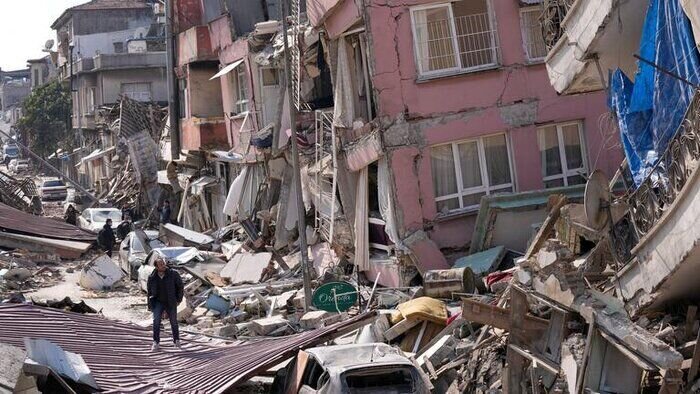
TEHRAN - An earthquake with a magnitude of 6.8 occurred on September 8, 2023, in Morocco, killing more than 2,000 people at 23:11 local time. This earthquake damaged buildings in villages and towns around the epicenter - about 70 km from the historical city of Morocco - and caused significant human and economic losses.
The severity of the earthquake in the high Atlas Mountains of Morocco caused numerous landslides and blocked roads in the mountainous region, and rescuers were trying to reach the affected remote areas on Saturday, so it is expected that the death toll may exceed 2,000 in the following days. It is announced that it will be extended until the morning of Sunday, September 10.
This earthquake is the biggest event in the last 120 years in this North African country. The Atlas Mountains in northwestern Africa are the prominent structure in the boundary zone between the converging African and Eurasian plates in the western Mediterranean. The Atlas Mountains range extends over 500 kilometers from the south of Iberia to the bottom of the Sahara.
Shortening across the central and western Atlas belt - in the area where the September 8, 2023 earthquake occurred - was measured at the pressure boundary of the intra-plate structural collision and the earthquake event was similar to the compression and strike-slip mechanism of the September 2023 earthquake in the same area. Is obtained. The Atlas Mountains extend approximately east-west for 2000 km from the Atlantic coast of Morocco to the Mediterranean coast of Tunisia, and the height of the mountain range reaches more than 4,000 meters.
During the Zimmuri-Boumardas earthquake in Algiers on May 31, 2003, twenty years ago, the author visited this area as part of the IIEES, and this visit to the 2003 earthquake was the beginning of a study that was carried out during 2003 and 2004 on the seismicity of the Atlas Mountains in the north. We did Africa. Such a study led to several joint studies of seismicity in the region of the Atlas Mountains and the Zagros and Alborz Mountains in Iran between Iranian, Algerian, and Maghrebi researchers in the following years.
Earthquake of September 8, 2023 Fault plate with seismic analysis of maps recorded in seismographic stations, with an azimuth direction of 255 degrees (northeast-southwest direction with north-75-east direction) and a slope of about 70 degrees to the southeast of it was a thrust fault with a small strike-slip component and a depth of 26 km.
Therefore, the September 8, 2023 earthquake is a classic and well-known tectonic earthquake. Marrakech High-Atlas in this region are raised by compressional tectonics and as a mud structure - or palm - on the northern border of the African sheet. The epicenter of the 2023 earthquake is located in the Haouz thrust fault zone.
Most of the shortening of the high-Atlas mountain range can be measured by its southern and northern boundary faults and it is controlled at two levels of decollement - rupture by folding from the bedrock. There is a shallow décollement surface at 1-4 km in the Tertiary layers and a deeper décollement in the middle crust at a depth of about 10-20 km in this area.
From the point of view of a tectonic earthquake, decoupling and rupture of the deeper fault in the crust has enough potential to cause destructive earthquakes, and with the depth of 26 km that we found for the earthquake of September 8, 2023, it seems that the epicenter of the 2023 earthquake started at the bottom of the deeper rupture. And then it moved towards the surface of the earth and the rupture of the fault has spread.
The northwest-southeast convergence of the Eurasian and Nubian (African) plates in the western Mediterranean region propagates inside the Nubian plate and affects the coastal zone of Morocco and the Atlas Mountains in the south of the coastal sector. Accurate positioning with GPS shows a shortening of about 1 mm per year in the north/south direction in the High Atlas Mountains, which reaches the Middle Atlas at a rate of about 2 mm per year.
Such a rate of deformation is similar to the rate of deformation in the area south of Alborz and in the north of Iran. The displacement of faults in the Tehran area is also about 1 to 2 mm per year. With this amount of deformation, we can expect an earthquake of 6 to 7 every 20 to 50 years, and every 200 to 500 years, there is a possibility of an earthquake with a magnitude of 7 to 7.5 in this area.
The two previous major and deadly earthquakes in Morocco are the February 24, 2004, Al Hoosima earthquake with a magnitude of 6.3 and 630 deaths, and the February 29, 1960, Agadir earthquake with a magnitude of 5.8 and 12,000 deaths. El-Asnam earthquake of 1980 in Algeria with a magnitude of 7.3 was one of the largest and most destructive earthquakes in Africa with about 5000 deaths in the 20th century.
The author is a professor at the International Institute of Earthquake Engineering and Seismology
