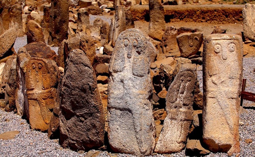
Shahr-e Yeri, nicknamed ‘City of the Mouthless’, to open to public

TEHRAN – Shahr-e Yeri, a unique archaeological site nicknamed ‘City of the Mouthless’ in northwest Iran, will be open to the public in the near future.
Over the past couple of years, the site underwent extensive restoration work to help safeguard its Iron-Age fortress, three prehistorical temples, and tens of stones, which bear bizarre-shaped mouthless faces.
A series of custom-made roofing covers and tourism amenities have been constructed over the ancient site, which is situated near Pirazman village of Meshkin Shahr in Ardabil province.
Massive shielding structures have been installed to protect the 400-hectare archaeological site against harsh natural conditions, according to local officials.

The archaeological site was inscribed on the list of national heritage sites in 1931. It embraces an Iron-Age fortress, three prehistorical temples, and tens of stones on which bizarre-shaped mouthless faces have been carved. In its heyday, bodies of the dead were buried with special ceremonies and rituals in compliance with religious beliefs… however, the majority of the tombs were found empty of skeletons due to illegal excavations, according to the Circle of Ancient Iranian Studies.
More than 10,000 ancient petroglyphs and rock-carved art have been discovered in and near Meshkin Shahr over the past couple of years. Some of the objects bear depictions of human beings in archery and cavalry in rhythmic and magical themes. There are also petroglyphs depicting mountain goats, boat anchors, shooting and scenes of war, and scenes of deer hunting in individual and collective forms.
Rock arts can be seen around mountainous regions across Iran where roaming life and livestock farming are prevalent typically. The rock-carved figures of animals and associated tools are regarded as good clues to help shed light on daily life in the distant past, though some figures might be symbolic.

The first well-documented evidence of human habitation in the Iranian plateau was found from several excavated cave and rock-shelter sites, located mainly in the Zagros Mountains of western Iran and dated to Middle Paleolithic or Mousterian times (c. 100,000 BC).
From the Caspian in the northwest to Baluchistan in the southeast, the Iranian plateau extends for close to 2,000 km. The land encompasses the greater part of Iran, Afghanistan, and Pakistan west of the Indus River, containing some 3,700,000 square kilometers. Despite being called a “plateau”, it is far from flat but contains several mountain ranges, the highest peak being Damavand in the Alborz mountain range at 5610 m, and the Dasht-e Loot east of Kerman in Central Iran, falling below 300 m.
AFM
