Damavand quake: A trigger of risk panic in Tehran

On 8 May 2020, 48 minutes after the midnight (local time), a moderate earthquake with a magnitude of 5.1 on the Richter scale shocked citizens of Tehran province. Most of the people were already in sleep.
The epicenter of the earthquake was in the vicinity of Damavand, a city 40km northeast of Tehran.
According to the 2016 national census, Damavand has 48,000 inhabitants.
It caused two deaths and 20 injuries. The two died because of the panic caused by the tremor. However, over a million people in Tehran left their homes and slept in parks or inside their cars.
The causative fault for the earthquake was Mosha fault, 5km north of the city of Damavand, has a history of major historical earthquakes in 958 A.D. in Rey-Taleghan with an estimated earthquake magnitude (EEM) of 7.7; 15 June 1665 with EEM 6.5 that caused landslide and created Taar lake in the vicinity of Damavand, actually a mountain promenade in Tehran province; 27 March 1830 EEM 7.1 in Shemiranat; 2 October 1930 EEM5.0 in Ah-Mobarakabad; 20 January 1990 EEM5.9 in Firouzkuh; and 9 May 2020 EEM5.1 in Damavand.
People living around the Mosha fault within a 25km distance are estimated to be around 300,000, while the inhabitants within its 50km are about 17.5 million, based on the 2016 census. This large population is concentrated in and around the megacity of Tehran and Karaj in the provinces of Tehran and Alborz.
There is a Mosha fault segment from Damavand towards northern Tehran, where it is estimated a locked part of the fault along about 100km length, at least since 27 March 1930 earthquake. Therefore, there is a probability of major earthquake triggered along this part of the Mosha fault close to Tehran.
Tehran is one of the most hazardous metropolises of the world in terms of the risk of different natural disasters, such as earthquake, flood, subsidence, drought, landslide, fire following an earthquake, etc. On the other hand, Tehran has over 8,300,000 night time population with a mixture of old non-resistant structures as well as modern high-rise buildings which affect the vulnerability of this city.
Risk of natural hazards is usually defined as below:
Risk = Hazard * Vulnerability * Exposure
Hazard represents the probabilities and intensities of a disaster. Vulnerability can be considered in terms of technical, physical, organizational, psycho-social or economic vulnerabilities, and the Exposure is the number or the amount of a target which is considered as elements at risk such as the population of a city.
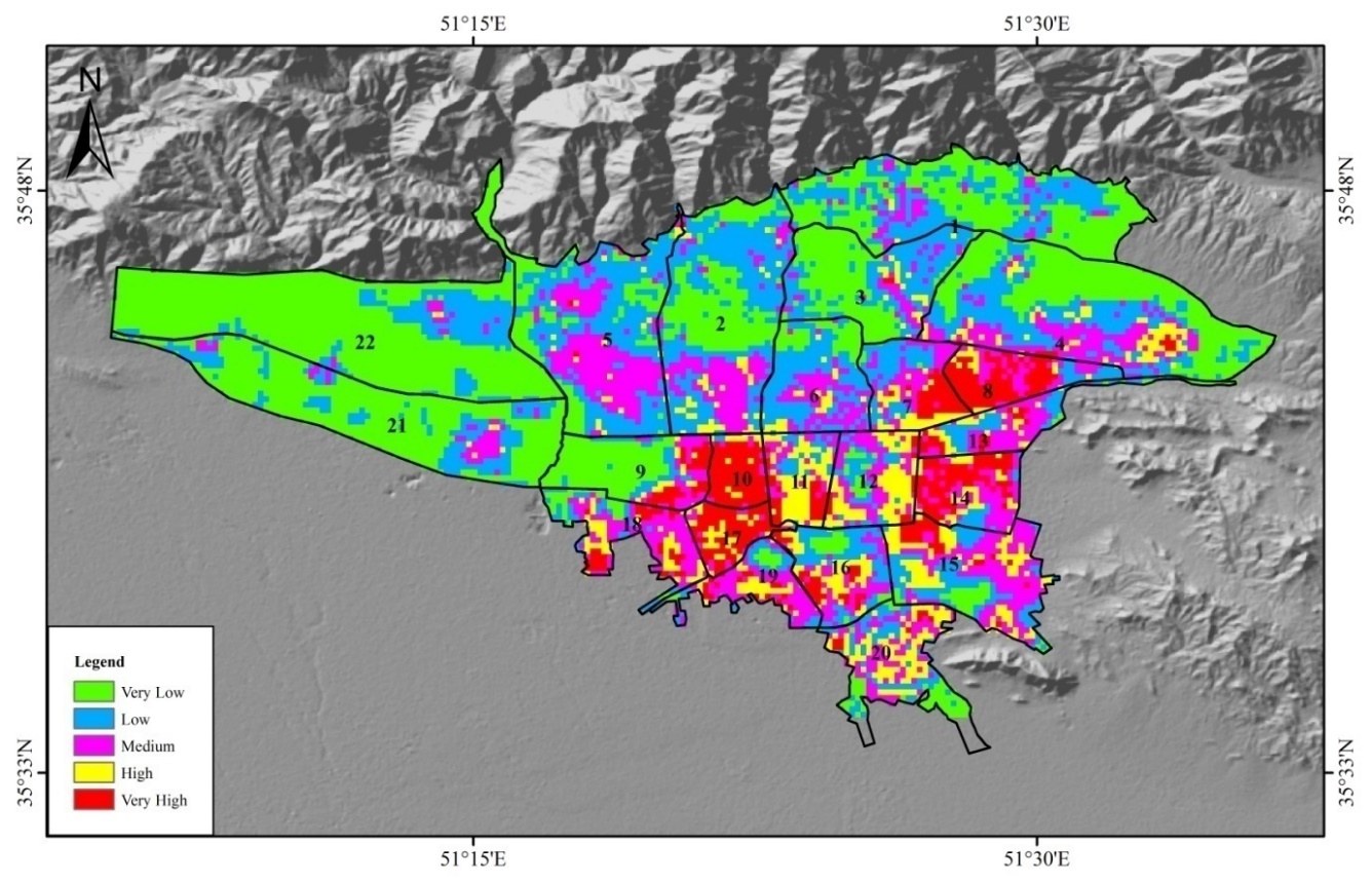
For the city of Tehran, the hazard assessment of earthquake, flood, landslide, and subsidence are performed to derive an overall multi-hazard map. Then, by combining the overall multi-hazard map with the distribution of non-resistant structures as the vulnerability factor and the population density as the exposure term, a risk map of the multi-hazards is prepared (Fig. 1).
The risk map of the multi-hazards in Tehran indicates that the central and southern regions of the city are located at a higher risk zone than other regions, so that the central and southern regions need a closer attention in disaster risk reduction plans.

Fig. 1. Risk map of the multi geo-hazards in Tehran (by Mehdi ZARE, 2015)
In addition, during the recent years, several researchers have attempted to model and assess the post-earthquake fire in urban areas. The recent serious fire incidents in single tall buildings in 2017 such as the fire in the Plasco Building (Fig2) in Tehran draws our attention to the fact that how resilient will urban areas be in case of an extensive post-earthquake conflagration? Therefore, modeling of the risk of earthquakes and their subsequent fires should be regarded as an important issue in disaster risk reduction strategies in urban areas, especially in the metropolises and large developing cities like Tehran.
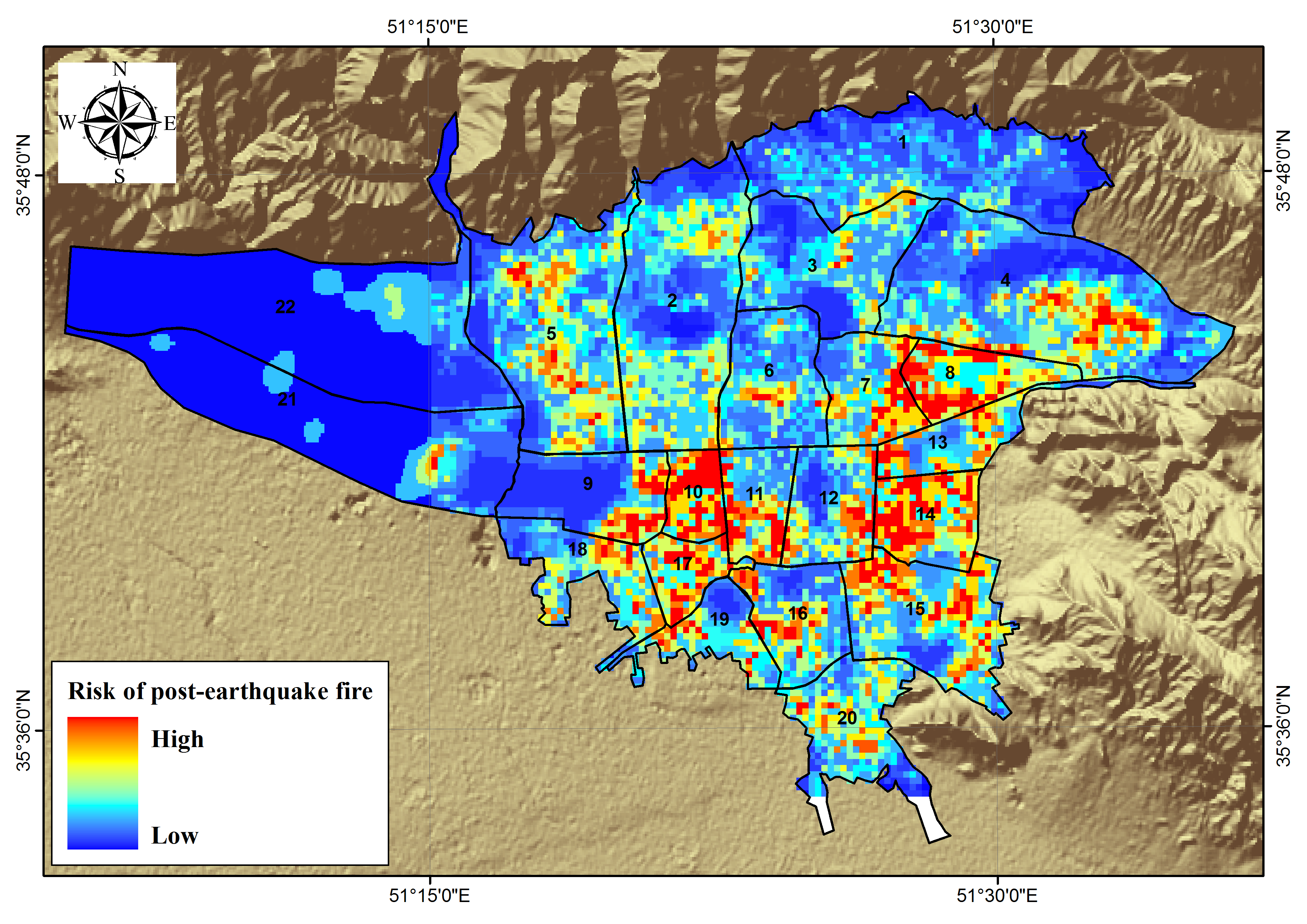
We have attempted to model the risk of probable post-earthquake fire in Tehran. At first, the earthquake hazard map was prepared by preparation and combination of two maps: a PGA map with 475 years return period for surface deposits using the probabilistic seismic hazard analysis and fault rupture hazard map. Then, a human exposure map was provided in terms of population density according to the latest census of Iran. Several vulnerability factors (Table 1) were depicted.
Based on the aggregation of these data, and overall vulnerability map was prepared. Finally, by multiplying the hazard map with the vulnerability and the exposure maps, the risk map of the post-earthquake fire was prepared for Tehran (Fig. 3) which indicates that the central and southern regions of this city are located at a higher risk zone.
| |
Fig. 2. Recent fire incidents in high-rise buildings in 2017: The 17-story Plasco Building in Tehran which was engulfed by a fire and fully collapsed on January 19, 2017
Table 1. Factors of risk of post-earthquake fire in Tehran
| Hazard |
Exposure |
Vulnerability |
| · Surface PGA · Surface fault rupture zone |
Population density |
· High-rise buildings (> 10 floors) · Buildings quality (high quality, moderate, worn out or non-resistant) · Narrow paths (width<10 m) · Accessibility to main streets, freeways and highways · Bridges and tunnels · Fire hydrant valves · Accessibility to fire station · Accessibility to hospitals · Strategic facilities (oil refinery, gas and water lines, etc) · Potential flammable places (wood and textiles warehouses) · Population centers (the great bazaar, malls, stadiums, etc) |

Fig. 3. Risk Map of post-earthquake fire in Tehran (by Mehdi ZARE, 2018)
Mehdi Zare is professor of engineering seismology at the International Institute of Earthquake Engineering and Seismology (IIEES) in Tehran. He is also associate member of Geology Division and the Academy of Sciences in Iran.
