A review of earthquake risk in Tehran

The city of Tehran is at risk of earthquakes, displacement, migration of population, and the vulnerability of buildings and bad excavations.
In the social dimension, informal settlements are common concerns, especially in suburban areas. For crisis management at the national level, the country's crisis management organization (Ministry of the Interior) and at the local level, Tehran Municipality conduct two the Tehran Crisis Management Headquarters, related to infrastructure provision and coordination; and Tehran Disaster Mitigation and Management Organization (TDMMO).
Tehran's water supply and treatment is in charge of the water and wastewater network that still has problems such as leakage. The wastewater network is now being developed. The road network (outside the city) is new and under development.
The old airport of Tehran "Mehrabad", which is located inside the city, is the terminal for domestic flights. Imam Khomeini International Airport (IKIA) is located some 30 kilometers southwest of the city. The old railway network is being developed.
Some important government and historical buildings and infrastructure are vulnerable according to structural engineering reports, and some are modern and safe. There is a plan to rebuild and modernize and retrofit schools (about 4000 units), and some of them have been renovated so far.
In terms of health facilities, the city has more than 200 hospitals and clinics that provide a variety of services, and according to the reports of the Ministry of Health, less than 20% are safe in an earthquake with a magnitude greater than 6.5 and about 47% are relatively prepared for severe earthquakes.
Earthquake risk assessment for Tehran has been done in order to provide an insight into the relative risk situation between different areas of Tehran and the possibility of relative comparison between them.
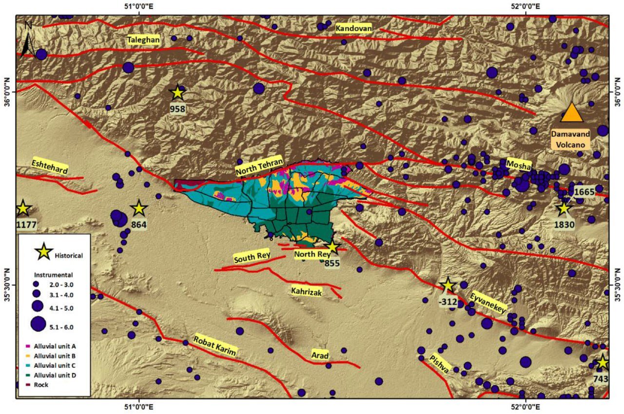
We used the latest data sets (such as a catalog of earthquakes, active fault map, geology, etc.) to assess the risk of earthquakes in Tehran. Exposure is then assessed based on population density distribution.
In addition to hazard and exposure analysis, vulnerability to the built environment was also analyzed using seven GIS-based vulnerability datasets (land use, urban context, building height, occupancy, structure type, and age, as well as the proximity of some critical infrastructures) have been evaluated and as a result, the earthquake risk has been calculated.
For the main, medium, and minor faults of Tehran, the surface rupture zone around the faults should be considered a high-risk area and prohibited for construction.
Tehran is in a seismic absence and a long silence in terms of earthquake occurrences after the last major earthquake events. The population density map of Tehran clearly shows that out of 22 Municipality districts in Tehran, eight districts are the densest districts of Tehran.
Comparing this human exposure to the general map of physical vulnerability, it is revealed that in some areas, the population is precisely concentrated in the most dangerous vulnerable places, which should be considered an urgent issue in future urban development efforts.
Based on the general map of physical vulnerability, 10 districts out of 22 in the Tehran metropolis, including districts 7, 8, 10, 11, 12, 14, 15, 16, and 17 show more vulnerability than others.
These results are in general agreement with some previous studies on the vulnerability of urban tissues and building loss models in Tehran. The overall risk map drawn as a result of the combination of risk, exposure, and vulnerability maps and shows an estimate of risk distribution in Tehran.
In general, it shows that the southern half of the city is more dangerous than the northern half. However, the level of risk should not be underestimated in other districts, especially the northwestern districts (i.e. no. 5 and 22) which are developed in the North Tehran fault zone and are also undergoing rapid urban expansion and development.
The comparison between our study and the previous study of physical-socio-economic risk assessment in Tehran shows that areas no. 10, 17, 20, 16, 15, and 11 have the highest risk.
The author is a professor at the International Institute of Earthquake Engineering and Seismology, Tehran, Iran.
Leave a Comment