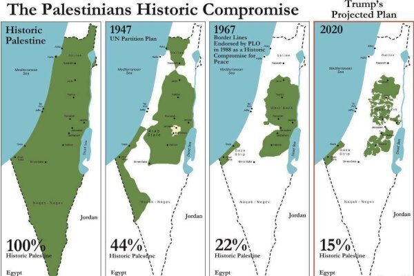
The examination of the map that Trump released for Palestine

TEHRAN - A look at the map released by U.S. President Donald Trump reveals that the West Bank and the Gaza Strip are surrounded by the lands occupied by Israeli.
Following the unveiling of the Deal of the Century, a map was released by Trump that worsened the situation.
Below we will review the details of the map.
- The West Bank will have no border with the Jordan River and the Dead Sea. Only two bridges to Jordan than cross through the Israeli territories will connect the West Bank with the outside world.
- A 24-kilometer tunnel will connect the West Bank with Gaza.
- The Israeli army will be in charge of safeguarding the West Bank.
- The West Bank will be like an archipelago with the Israeli territories located in it. In fact, Israeli settlements have destroyed its entirety.
- A number of settlements will be inside the Palestinian Territory that are linked to the Israeli territories and the Zionist regime’s army will be authorized to enter them. These settlements are apart from those in the West Bank and some other areas where Israel has annexed (since 1967).
- The West Bank will have no border with the Dead Sea and Palestinian residents of the West Bank can only use a part of the sea’s coast, which is under the Israeli sovereignty. In fact, their tourist use is limited and no part of the coast belongs to Palestine.
- Palestinian residents of the West Bank will have no access to Tel Aviv’s Ben Gurion Airport, and only two bridges to Jorden through the Israeli occupied lands connect them to the outside world. The Amir Mohammad Bridge links Nablus to Jordan and the King Hussein Bridge connects the city of Jericho with Jordan.
- 70% of the West Bank (967) is actually given to Palestine and the remaining 30% is given to Israel. Instead, two (industrial and agricultural) areas added to the Gaza Strip, which is less than the 30% that Israel has annexed in the West Bank. These two areas will have no border with Egypt. The new areas in the Gaza Strip are agricultural and industrial settlements, likely to be secured by Israel. The first area is in fact the current Gaza Strip that borders Egypt for 12 kilometers by the Rafah border crossing.
- The two agricultural and industrial zones annexed to Gaza have no border with Egypt and are linked by a narrow strip. The annexation of these areas, which are to be handed over to the Palestinian state is vague.
- The Palestinians will not be allowed to establish a port on the Gaza border along the Mediterranean Sea.
- Palestinian resistance groups in Gaza must be disarmed.
- Al-Quds (Jerusalem) will be the capital of Israel, and a small area of East al-Quds will be considered as Palestine’s capital.
- The West Bank will be completely surrounded by the Israeli occupied territories and will be controlled by the Israeli military. The only area of Palestine that will have border with the outside world is the Gaza Strip that stretches 12 kilometers along the Mediterranean Sea and Palestinians are unlikely to be allowed to establish a port there. The Rafah border crossing has already been under Egypt’s control.
Leave a Comment