Israel's war on Gaza
![Smoke billows following Israeli strikes on the Islamic University of Gaza (IUG), on October 11, 2023 [Saleh Salem/Reuters]](https://media.tehrantimes.com/d/t/2024/10/08/4/5198005.jpg?ts=1728388976732)
Gaza, home to some 2.3 million people, bears little resemblance to what it was a year ago.
Israeli attacks have reduced entire neighborhoods to rubble, erased centuries-old mosques and churches and destroyed vital agricultural lands.
The scale of destruction in this small area of just 365sq km (141sq miles) is so immense that many residents cannot return home - and likely won't be able to for the foreseeable future.
Satellite images from Al Jazeera’s digital investigation team, Sanad, reveal cratered terrain, scorched farmlands and the grey ruins of flattened buildings.
Attacks on refugee camps
Jabalia, located in North Gaza, is the largest of the Gaza Strip's eight refugee camps.
The camp, established in 1948 after Zionist military forces displaced more than 750,000 Palestinians from their homes, covers an area of only 1.4sq km (0.54sq miles) and is among the most populous in the Strip.
The Israeli military has repeatedly hit the camp of some 116,000 registered refugees, with United States-made 2,000-pound bombs, killing hundreds of people.
These bombs are among the largest and most destructive and can leave craters with a diameter greater than 40 feet (12 meters). a year of war
Attacks on mosques and churches
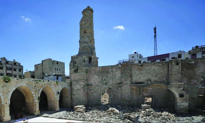
The remains of the largest and oldest mosque in Gaza, the Great Omari Mosque, also known as the Great Mosque of Gaza, are shown on April 6, 2024 [Dawoud Abo Alkas/Anadolu Agency]
About three kilometers (1.9 miles) south of Jabalia is Gaza's Old City, home to some of the Middle East's oldest cultural heritage sites, dating back to the 5th century.
Among its notable landmarks are significant places of worship, including the Great Omari Mosque, known as Gaza’s Great Mosque, and two of Gaza’s prominent churches: St Philip the Evangelist Chapel and the Church of Saint Porphyrius.
On December 8, Gaza’s Great Omari Mosque suffered extensive damage in an Israeli air strike. Its 747-year-old library, once home to rare manuscripts including old copies of the Quran, was left in ruins.
In the past year, Gaza's Government Media Office has recorded the complete destruction of at least 611 mosques and the partial destruction of 214 mosques due to Israeli attacks.
All three of Gaza's churches have been targeted and damaged by Israeli attacks.
The Greek Orthodox Church of Saint Porphyrius, located less than 300 meters (984ft) from the Grand Omari Mosque, was hit by an Israeli missile on October 19, killing 17 people who were sheltering inside.
Attacks on schools and universities
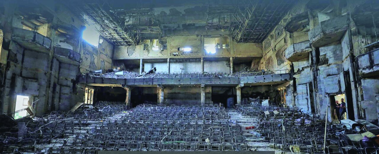
A charred hall in the Islamic University of Gaza (IUG), on April 28, 2024 [Dawoud Abu Alkas/Reuters]
Not far down the road from the Old City, in the heart of Gaza City's Remal neighborhood, is the Islamic University of Gaza (IUG).
IUG, together with al-Azhar University, are the two top universities in the Gaza Strip, providing higher education to tens of thousands of students each year.
While both universities have been targeted in previous wars, this latest war has left their campuses completely devastated.
The Geneva-based independent Euro-Med Human Rights Monitor said that Israel systematically destroyed every university in Gaza in stages.
Of Gaza’s 12 universities, none is left standing.
Attacks on hospitals
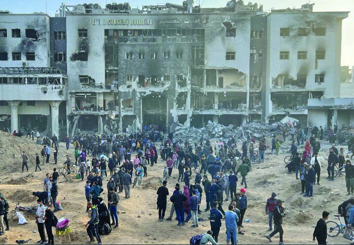
Palestinians inspect the damage at al-Shifa Hospital following a two-week Israeli offensive, on April 1, 2024 [Dawoud Abu Alkas/Reuters]
Still in Remal neighborhood is al-Shifa Hospital, the largest medical complex in the Strip and one of the first hospitals to come under attack.
On November 15, Israeli soldiers surrounded the medical complex where thousands of Palestinians were sheltering. Five months later in April, it came under a two-week siege that left the hospital in ruins and hundreds of people dead.
Several experts have argued that attacking hospitals – especially those treating critically ill patients and babies – could be a war crime as defined under international law.
Over the past year, at least 114 hospitals and clinics have been rendered inoperative, leaving many patients without access to essential medical services.
Splitting Gaza in half
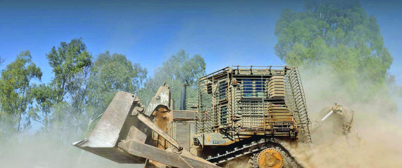
An Israeli bulldozer manoeuvres near the Israel-Gaza separation fence, on June 6, 2024 [Amir Cohen/Reuters]
In addition to the widespread destruction in Gaza, the boundaries of the enclave have also been shrunk by the creation of Israeli buffer zones.
The Gaza Strip has been pushed inward and a 1.5km-wide (0.93-mile) strip that runs 6.5km (four miles) across the middle in the Juhor ad-Dik area, known as the Netzarim Corridor.
Satellite imagery, taken between August 8 and 27, revealed Israeli troops fortifying the Netzarim Corridor - a six-kilometer-long (four-mile) road just south of Gaza City running east to west from the Israeli border to the Mediterranean Sea.
Military analysts have said that the carving is part of a ploy to reshape the Gaza Strip and fortify an Israeli military presence there.
Destruction of agricultural land
Further south, in central Gaza, lies Deir el-Balah, one of Gaza's main agricultural hubs, known for its cultivation of oranges, olives and, notably, dates.
The satellite images show the widespread destruction of farms, roads and homes in eastern Maghazi in the center of Deir el-Balah.
Satellite images analyzed by Sanad reveal that more than half (60 percent) of Gaza's farmland - crucial for feeding Gaza’s population of which 96 percent is food insecure, has been damaged or destroyed by Israeli attacks.
Two million forced from their homes
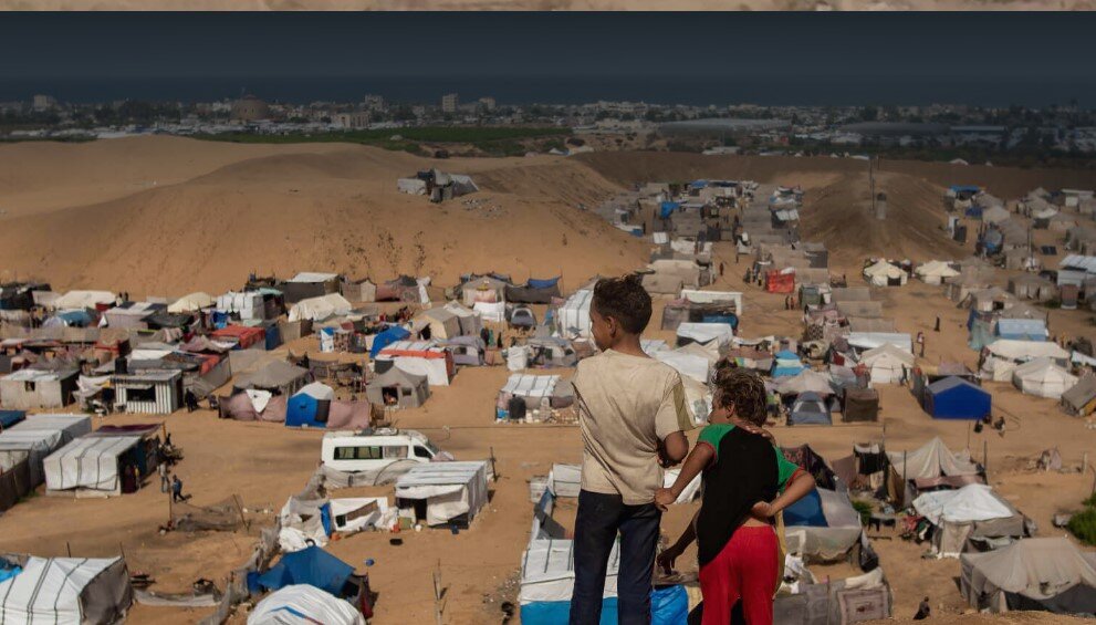
Two children stand at an area overlooking tents at a camp for displaced people in Khan Younis, on September 22, 2024 [Haitham Imad/EPA]
On October 13, ahead of an anticipated ground offensive, the Israeli army ordered the evacuation of all civilians living in Gaza City and in the north of the Gaza Strip.
At this point, Gaza was in its seventh day of a total blockade in which Israel’s Defence Minister Yoav Gallant stated, “No electricity, no food, no water, no gas – it's all closed."
With more than 80 percent of the Gaza Strip deemed unsafe for Palestinians, due to either being designated as a “no-go zone” by Israel or evacuation orders, humanitarian zones were the last bastion of safety for many. However, even these pockets of land have begun to shrink.
In search of safety, hundreds of thousands of Palestinians fled to al-Mawasi, a narrow strip of sandy terrain along Gaza's coast.
Despite being designated a humanitarian “safe zone” by Israel, it has conducted dozens of attacks there, killing hundreds and wounding many more there, highlighting the frightening reality that there is no safe place in Gaza.
Utter destruction
In just one year of war, the landscape of Gaza has altered almost unrecognizably.
According to satellite image analysis based on Sentinel-1 radar data by researchers Corey Scher of CUNY Graduate Center and Jamon Van Den Hoek of Oregon State University, almost 60 percent of Gaza has been damaged or destroyed including:
* 69.3 percent in North Gaza
* 73.9 percent in Gaza City
* 49.1 percent in Deir el-Balah
* 54.5 percent in Khan Younis
* 46.3 percent in Rafah
An estimated 75,000 tons of explosives have been dropped on Gaza with experts predicting it could take years to clear the debris amounting to more than 42 million tons, which is also rife with unexploded bombs.
